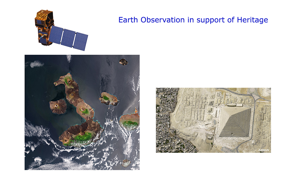
To the right: Galapagos (Ecuador) a Natural World Heritage site taken by Sentinel 2 at 10m resolution (c) Contains modified Copernicus Sentinel data processed by ESA.
To the left: Pyramids of Cairo (Egypt) a Cultural World Heritage site taken by Airbus-Pleiades at 30cm native resolution.
(c) AirbusSpace #PléiadesNeo #SpaceMatters
Introduction
EARSeL, as the European Association of Remote Sensing Laboratories, is always interested in new applications. In this sense, for more than 15 years, EARSeL has been promoting the establishment of expert networks and associated research on the topic related with the use of Remote Sensing to support Cultural and Natural Heritage.
Recently, Earth Observation technology has represented a primary source of geo-information to support national and local authorities and conservation institutions in managing and monitoring Heritage sites. Applications include preservation actions for valorization plans, sustainable tourism processes, buried features identification, as well as artificial and natural risk monitoring such as looting and climate change effects on cultural landscapes, from early warning and rapid mapping to post-disaster analysis and damage assessment.
In particular, the last 15 years have brought a series of new data capture sensors as well as tools. Such remote sensors include satellite images (different resolutions), laser scanning, rapid prototyping, Red-Green-Blue-DEPTH (RGB-D) sensors, high dynamic range imaging, spherical and infrared imaging, mobile mapping systems, Unmanned Aircraft Systems (UAS), based imaging, augmented and virtual reality, to cite a few. The overall fusion of all this data is extremely useful to derive applications in support of Natural and Cultural heritage sites.
Without question, Cultural heritage has been elaborating complex Digital-Twins-Heritage applications such as virtual tours and virtual and augmented reality. All these technologies, together with Artificial Intelligence techniques and EO data source derived information, can significantly support the Digital Earth Twin concept.
The targeted audience of this Special Interest Group is a particular multidisciplinary set of actors. The range of actors and stakeholders involved in cultural heritage preservation, discovery and restoration that might take advantage of space derived information is really wide: it might include archaeological parks management, companies providing virtual tours, archaeological research institutes and specialists, environmental organizations, governmental authorities etc. Obviously EO experts are included but they do have the challenge of avoiding using EO technological terms and instead use a terminology understandable by natural and cultural heritage authorities.
The SIG pays particular attention to interdisciplinarity activities, therefore joint activities with other EARSeL SIGs will be implemented as possible. One of the SIG’s objectives is to foster collaboration, support networking and information sharing, feel free to contact the SIG chairperson and join the next Cultural and Natural Heritage events!
Topics
Focus topics of the SIG cover the integration of a set of traditional and innovative technologies for protection and valorization of Cultural and Natural Heritage. Remote sensing and associated digital techniques supporting heritage documentation, preservation, protection and presentation, cover a wide range of technologies, mainly grouped in three major areas: data capture, virtual reconstruction, and visual communication. Advances in science and technology facilitate today the elaboration of accurate 3D models of heritage sites features. Heritage 3D models might range from modelling the whole landscape with a resolution of meters (m) by using high-resolution satellite images, to the modelling of, for example, small archaeological features (e.g., small pottery artifacts) with a resolution lower than 1 mm. On the space technology side, EO scientists still consider it one of the most effective way to measure the impact that climate change and disasters (fire, floods, hurricanes and earthquakes) are having on cultural landscapes, thus assisting sites and heritage managers with mitigation and adaptation and benefit from the systematic approach used in the disaster risk management field. In fact, modern technologies in space can be used to monitor the effects of natural disasters, providing support for the entire disaster life cycle: from early warning and rapid mapping to post disaster analysis and damage assessment.
Opportunities for EO science and technology
Capacity building and communication still represent two powerful means to reach all the involved actors and new stakeholders such as local and governmental authorities, cultural heritage managers, museums, archaeological parks, environmental organizations, prosecutors and citizen community. There is the need to strengthen the communication and the synergies between EO experts and Cultural Heritage managers through dedicated capacity building initiatives as intensive online courses (MOOC), trainings, information sharing. Also, the provision of user-ready products (connection between the data providers and the end-users – site managers) and supporting the generation of processes and practices for technology and Cultural Heritage are two fundamental steps towards a more effective EO contribution to the long-term actions for natural and cultural heritage preservation and fruition. Earth Observation data is becoming increasingly instrumental, with numerous projects and applications aimed at providing products tailored to the needs of cultural heritage. Satellite data are essential for monitoring our cultural and natural heritage worldwide, helping to preserve the irreplaceable archaeological records for future generation and the multidisciplinary approach is fundamental in this respect.
With these premises, we are surely close to a future and systematic methodology that can be applied to the monitoring, preservation and management of Natural and Cultural Heritage in the next future.
Co-chairs
Dr. Jolanda Patruno
Earth Observation Engineer at the Rhea Group (email)
Dr. Mario Hernandez
Vice President International Society for Digital Earth / EARSeL Honorary Member (mariohernandezvaldes@gmail.com)
Sessions on Remote Sensing for Cultural Heritage within EARSeL Symposium Since the establishment of the SIG on Natural and Cultural Heritage there have been almost always a session dedicated to this this topic during the EARSeL Symposium.